A danger to life warning has been issued for this weekend with flooding, heavy rain and 80mph winds expected as Storm Darragh batters large parts of the UK.
The fourth named storm of the season is expected to bring heavy rain this afternoon and into the weekend, while 130 flood alerts have been issued.
A yellow warning for rain will be in place for Northern Ireland and Wales, which were badly affected by flooding during Storm Bert, from 3pm today until 12pm tomorrow.
Rhondda Cynon Taf, where between 200 and 300 properties were flooded during Storm Bert last month, is set to be hit by heavy rain once again.
The Met Office said the wind may cause disruption to travel, with difficult driving conditions likely. National Highways, which runs the UK’s motorways and busiest A-roads, has issued a severe weather alert for Saturday.
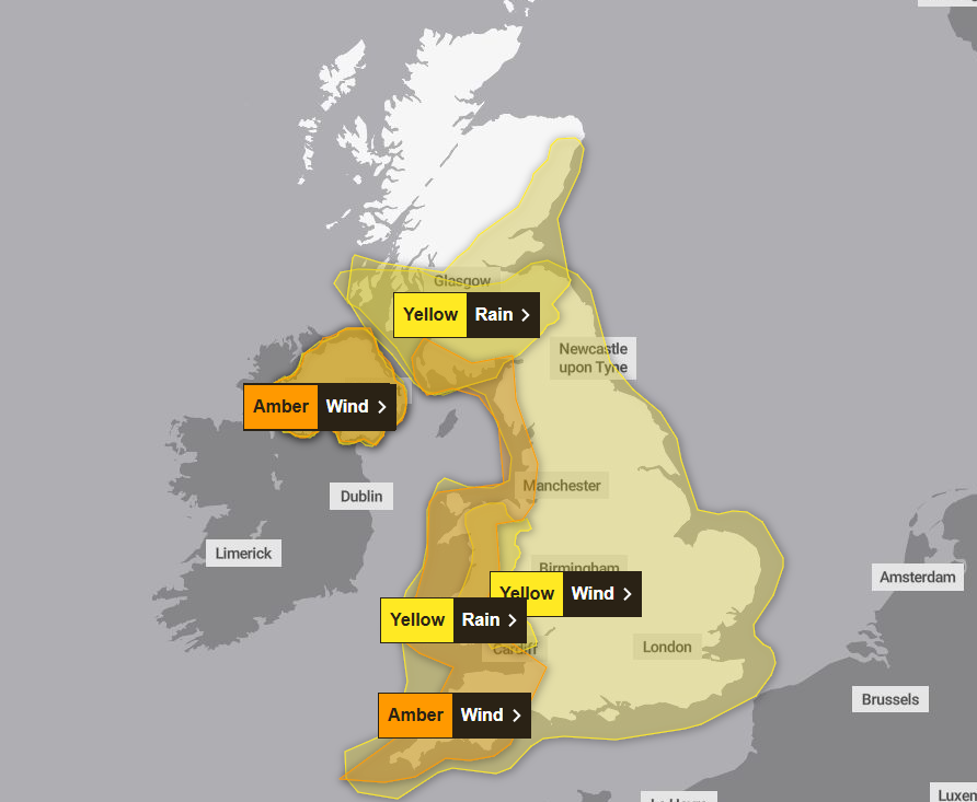
Two amber weather warnings on Saturday for “potentially damaging winds” are in place for Northern Ireland and the entire west coast of England and Wales, along with southwest Scotland. A danger to life warning is in place for these areas.
Storm Darragh mapped: Which areas will face a ‘danger to life’ ?
Storm Darragh is set to batter parts of the UK with up to 80mph winds, torrential rain, and potential flooding over the weekend.
The Met Office has issued a number of yellow and amber weather warnings, as it predicts a possible “danger to life” in western parts of the UK where wind speeds are expected to reach the highest.
Thursday into Friday
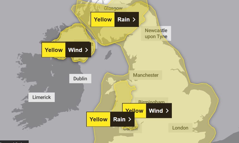
A yellow weather warning for wind has been in place since 3pm yesterday. It covers much of southern England, all of the Midlands and parts of northwest England.
Wales, the Scottish west coast and Northern Ireland are also covered by the weather warning, which will remain in place until 3am today. The Met warns that “disruption” is possible due to gusty winds.
Alisha Rahaman Sarkar6 December 2024 04:45
Yellow warning for rain in place for Northern Ireland and Wales

Alisha Rahaman Sarkar6 December 2024 04:15
About 130 flood alerts in place as Storm Darragh approaches
Strong winds and rain will bring a “risk to life and property” across the UK, the Met Office said, as Storm Darragh approaches.
The fourth named storm of the season is expected to bring winds of up to 80mph and heavy rain this afternoon and into the weekend, while 130 flood alerts have been issued.
A yellow warning for rain will be in place for Northern Ireland and Wales, which were badly affected by flooding during Storm Bert, from 3pm today until 12pm tomorrow.
Up to 60mm of rain could fall in these areas during the warning period, which may lead to some flooding and disruption, forecasters said.
Rhondda Cynon Taf, where between 200 and 300 properties were flooded during Storm Bert last month, is set to be hit by heavy rain once again.
Alisha Rahaman Sarkar6 December 2024 03:46
Environment Agency issues warning to drivers
The Environment Agency has urged drivers not to drive through flood water this weekend.
Katharine Smith, flood duty manager from the agency, said heavy rain was expected to move “rapidly” across the north and west of England on Thursday evening, adding minor surface-water flooding was “probable” across parts of northwest England, while minor river flooding was possible more widely across the country.
“Environment Agency teams are out on the ground and will support local authorities in responding to surface water flooding. We urge people not to drive through flood water – it is often deeper than it looks, and just 30cm of flowing water is enough to float your car,” Ms Smith said.
Alex Croft6 December 2024 03:00
Storm Darragh mapped: Which areas will face a ‘danger to life’ amid 80mph winds and flooding?
The forecaster says a period of “very strong northerly or northwesterly winds” will develop throughout Saturday as Storm Darragh moves from west to east. This will see gusts of up to 70 to 80 mph hit areas of exposed coast and gusts of 60 to 70 mph in inland areas.
Affected communities, particularly those under an amber weather warning this weekend, are warned to stay cautious and to avoid driving due to potentially dangerous conditions.
With several weather warnings for wind and rain covering different areas at different times, The Independent has broken down which areas will be affected.
Alex Croft6 December 2024 01:00
National Highways issues driving advice
Drivers have been advised to “adjust your driving behaviour” if weather conditions become challenging.
Duty manager at National Highways Dale Hipkiss said: “If you’re planning to drive over the next few days, prepare in advance for the journey and take extra care on the roads.
“If weather conditions become challenging, adjust your driving behaviour to manage the conditions as safely as possible. It’s also a good idea for drivers to check their vehicles, such as tyres, coolant and oil levels, before heading out to reduce the risk of breakdowns.”
Alex Croft5 December 2024 22:59
What is causing Storm Darragh?
Storm Darragh follows a period of “unsettled and squally conditions”.
An area of low pressure will bring strong winds and heavy rain to much of the UK, with the heaviest rainfall expected to be focussed in the northern and western parts of the warning area.
Some snow will hit northern areas above 200m, the forecaster said.
Met Office chief forecaster Jason Kelly said: “Storm Darragh is an evolving system and will bring several hazards, including wind gusts of up to 70-80mph around western coasts, especially from Devon and Cornwall to southwest Scotland and Northern Ireland. Wind speeds in inland areas will be slightly reduced with maximum gusts expected to reach 60-70mph.”
Alex Croft5 December 2024 21:55
How to stay safe in strong wind
The Met Office has issued its top tips for staying safe in areas with strong wind over the weekend.
Here’s what to do if Storm Darragh brings gusty winds to your area, according to the Met:
- Protect your property: ”Don’t risk injury to others or damage to your property. Check for loose items outside your home and plan how you could secure them in high winds,” the forecaster says.
- Plan routes and pack essentials for any journeys: The forecaster stresses that “windy weather can cause delays and make driving conditions dangerous.”
- Drive slowly and cautiously in strong wind: “Driving in these conditions can be dangerous, for yourself and other road users,” says the Met Office.
- Take when near coast: Check forecasts and tides and be aware of large waves, the Met Office says. Take care walking near cliffs.
- Stay indoors as much as possible: “Being outside in high winds makes you more vulnerable to injury. Stay indoors as much as possible. If you do go out, try not to walk or shelter close to buildings and trees,” the Met Office says.
Alex Croft5 December 2024 20:52
Mapped: Where will Storm Darragh hit?
Friday afternoon: Storm Darragh hits
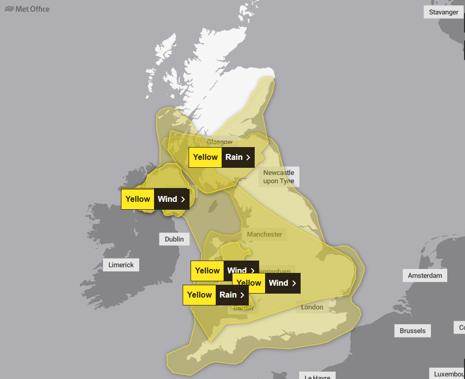
Three yellow weather warnings for rain and wind will be introduced at 3pm. A yellow warning for wind from 3pm on Friday until 6am on Sunday will cover the entirety of England, Wales, Northern Ireland and southern parts of Scotland.
A yellow weather warning for rain will cover Northern Ireland and most of Wales from 3pm on Friday until 12pm on Saturday, with the possibility of some “flooding and disruption”.

Another yellow warning for rain will cover the southern part of Scotland from 3pm on Friday until 12pm on Saturday, stretching from the Scottish Borders up to Glasgow and Edinburgh, and up the eastern coast to Aberdeen.
Saturday: Severe wind strikes
Alongside the yellow weather warnings starting on Friday, two amber warnings for wind will be introduced in the early hours of Saturday.
The warning, in force between 3am and 9pm on Saturday, encompasses southwest England, western Wales, England’s northwest coast and the southeastern coast of Scotland.

Alex Croft5 December 2024 19:49


